NPS Website
 WHAT IS IT?
Ruins of 12th through 16th century Ancestral Puebloan cliff dwellings and freestanding villages situated at the bottom of Frijoles Canyon and tucked between the sheer cliffs of forested plateaus.
BEAUTY (7/10)
You approach Bandelier NM on New Mexico Route 4 along the top of the Pajarito Plateau. Other plateaus, separated from each other by deep, narrow canyons, rise to similar heights in all directions. The road passes a monstrously sized satellite dish before it switchbacks down the canyon walls and into the Park. A glance at the Park map reveals that the dish belongs to the Los Alamos National Laboratory, birthplace of the Atomic Bomb.
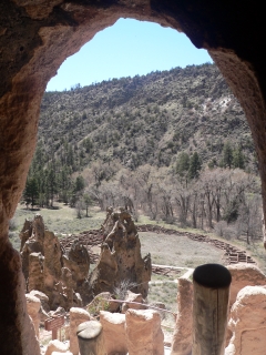
After a nearly 1,000-foot descent, the Park elicits a feeling of isolation. The forest is thick, the cliffs rise precipitously and Frijoles Creek audibly rushes as it flows towards the nearby Rio Grande.
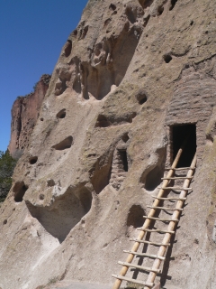
The Ancestral Puebloan cliff dwellings are a camouflaged companion to the Swiss cheese-like rock they have been built into. The ancient windows and doorways are distinguished only from the rock indentations by the ladders that extend from their entries. The D-shaped ruin of the freestanding Tyuonyi village speaks of the masses that once lived in this dramatic setting.
HISTORICAL INTEREST (4/10)
A specific culture of people settled, farmed and lived at the bottom of Frijoles Canyon for over 400 years. Their hunter-gathering ancestors roamed in and out of the same area for at least 10,000 years. No one had ever settled on top of the Pajarito Plateau until the 1940’s, when a 300-year old culture moved in and created a weapon that could immediately end the lives of millions of people.
CROWDS (7/10)
A sunny early-April Wednesday brought more people to the Site than we ever expected. A large group of school kids prevented our first attempt at the museum, but their excitement infected us. So we headed onto the Main Loop Trail and into the cliff dwellings.
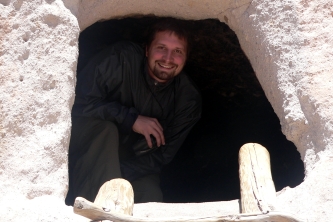
Ahead of us, a giddy family of four climbed up a ladder and into a prehistoric cave dwelling. “Wouldn’t it be cool to camp here,” the mother asked her 8-year old girl. Her response was “yes, but only for a few days.” We could not wait to follow their lead up. During the rest of the trail, neither the family nor we missed a chance to scurry up every ladder.
 EASE OF USE/ACCESS (3/5)
The Site is 47 miles northwest of Santa Fe, N.M. via United States 84/285, N.M. Route 502 and the N.M. Route 4. The closest town to Bandelier NM is Los Alamos, located about 10 miles to the north.
The Main Loop Trail is paved and its first ¼ mile (up to the point where you start going into the cliff ruins) is wheelchair accessible.
CONCESSIONS/BOOKSTORE (4/5)
The Site’s compact bookstore packs in a large array of local Native American titles and at least 15 books specific to Bandelier itself, including one written by Adolf Bandelier, the pioneering archeologist for whom the Park is named. We would have liked to have seen more than four Los Alamos-related books, but for the most part, Bandelier NM ignores its more destructive neighbor. If you want to read about the development of the atomic bomb, the Bradbury Science Museum bookstore stocks hundreds of titles on the subject.
COSTS (2/5)
Entry is $10 per vehicle, free with the National Parks Pass.
A $1.00 guidebook details the ruins situated along the Site’s primary hike, the Main Loop Trail. Bandelier NM was the only Park in the Southwest that did not provide a used “house copy” that could be returned without fee after the hike.
We generally buy the self-guided trail books after our hike, the only exceptions being when the brochure is sub-par or gives us no new information. We were dismayed and angered by the lack of trust endeared by the staff at Bandelier NM towards their visitors and did not blindly buy their booklet.
RANGER/GUIDE TO TOURIST RATIO (1/5)
There were no Rangers anywhere despite an overflowing parking lot full of people.
TOURS/CLASSES (5/10)
The Bandelier NM intro video is short on educational information and a victim of a poor location. The noise from the nearby bookstore and VC entrance make concentration difficult. Neither the video nor the Museum mentions the massive volcanic eruption that created the area’s unique topography.
We did enjoy the Museum’s mannequin-based recreations of cliff-dwelling life as well the extensive exhibit on FDR’s Civilian Conservation Corps, the depression-era young men who transformed the National Parks System. We did not sample the Main Loop self-guided trail booklet because of our aforementioned stubbornness. We did find discarded Falls Trail and Tsankawi Trail booklets in the parking lot. They are both well done and meaty with information.
FUN (6/10)
Ancestral Puebloan cliff dwellings can be fun, especially when you can climb in, on and around them. The Main Loop Trail combined with the Frijoles Canyon Nature Trail is an enjoyable way to spend an afternoon.
The extensive backcountry trail system that winds through the canyons and in between the plateaus could be a terrific place to find solitude, remote Indian ruins and a high altitude respite from the summer heat. The wilderness around Bandelier NM begs for exploration.
Our visit coincided with an early spring cold spell so we decided against staying at the 94-site Juniper Campground. The campground is situated near the Park entrance, on top of the plateau and at a 6,600 feet elevation. We may have reconsidered if we could have slept in the cozier environs of the lower canyon and if Michael had not been sick.
 WOULD WE RECOMMEND? (4/10)
Bandelier NM is not a place to plan a vacation around unless you live in northern New Mexico. As a day trip from Santa Fe, a short tour of Bandelier NM’s cliff dwellings makes a nice pair to the frightening and free Bradbury Science Museum, the promotional wing of the Los Alamos National Laboratory.
TOTAL 43/80
www.usa-c2c.com
© 2005