NPS Website; Local Website
WHAT IS IT?
 Home to North America’s largest, at 22,000 acres, intact floodplain forest. What that means is a great diversity of tall trees, a swamp-like feel, lots of birds and even more mosquitoes.
BEAUTY (6/10)
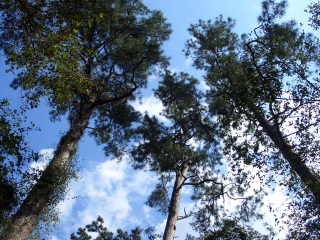
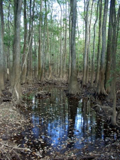
Trees of all types tower above and a life-providing musty stench fills the air even in the dry, cool season. Woodpeckers hammer away above and numerous wood warblers appear to the patient eye. Bald cypress trees are everywhere. Their familiar knees sprout up amid the recessed plains and meandering streams.
Still, Congaree NP’s beauty takes some convincing. The trees are some of the tallest east of the Mississippi but they do not feel overwhelming, perhaps because of the vast undergrowth and multiple canopy levels. Why did loggers destroy this precious natural ecosystem with such revolting abandon? Maybe it was not stunning enough.
HISTORICAL INTEREST (4/10)
In the late 19th Century, there were 52 million acres of old-growth floodplain forests in the southeastern United States. In just 50 years, logging companies harvested nearly all of these forests. Today, Congaree NP’s 11,000 acres of old-growth floodplain forest make it the largest example of this ecosystem in North America. The second largest old-growth floodplain forest totals just 2,000 acres.
Congaree NP’s excessively wet climate initially protected it from logging interests but in the 1950’s, conservationist Harry Hampton launched a passionate campaign to save this precious example of the earth’s natural past. A bitter fight between conservationist and loggers ensued, ending when the Congress set aside the land as Congaree Swamp National Monument in 1976. Congaree NP became an International Biosphere Reserve in 1983.
In 2003, the word swamp was dropped from the Site’s name (making the title ecologically accurate) and it became a National Park. Visitation numbers and interest spiked proving that marketing matters even in the National Park Service.
 CROWDS (5/10)
We skirted around several small groups of walkers on the low and elevated boardwalk trails. Their loud whispers and echoing clompety-clomp feet made bird watching tough. Their ubiquity made photography difficult.
The easy solution is: take the longer, more isolated, non-boardwalked Weston Lake Loop, Oakridge and Kingsnake Trails.
EASE OF USE/ACCESS (4/5)
Congaree NP feels like a wildly remote swampy nowhere, but actually sits just 20 miles to the southeast of South Carolina’s capital, Columbia. No National Park is closer to a State Capitol building. South Carolina Route 48 (Bluff Road) runs right past the Park’s entrance and stretches from Interstate 77 (near Columbia) to U.S. Route 601.
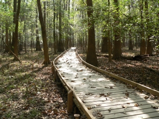
An accessible 2½-mile loop boardwalk trail takes you from the Visitor Center into the soaring trees of the floodplain forest. If you are slightly adventurous, additional trails lead into the primordial madness. Canoe put-ins and Bannister Bridge and Cedar Creek allow for further exploration. The great majority of the Park, however, is an unreachable, murky wilderness.
CONCESSIONS/BOOKSTORE (2/5)
The bookstore is nice but consists only of nature identification handbooks. The Park’s history and beauty, like the land whose memory it protects, feels forgotten.
COSTS (4/5)
Entry is free.
RANGER/GUIDE TO TOURIST RATIO (3/5)
Ranger-led events like canoe trips and “owl prowls” are limited to weekends and reservations (up to six weeks in advance during spring and fall) are required for most.
TOURS/CLASSES (3/10)
 There is an introductory film at the Visitor Center. It is safe to say it is forgettable, as neither of us can remember what it was about.
Displays in the VC alert viewers to the headlines and controversy surrounding the now protected old growth trees. An exhibit named “Great Trees or Coffee Tables?” chronicles the activism that saved what remains of the bottomland forest.
Other NPS wetland areas we have visited are still under threat from loggers and developers, despite their status as federal lands. We wished there were more opportunity to interact with Rangers to learn if this is the case with Congaree. There is only so much a two-dimensional display can say.
FUN (5/10)
The accessibility of boardwalk trails is both a blessing and a curse. Elevation gain minimal to non-existent – good. Dry feet – good. Safe place to perch while taking pictures of bright green snakes – all very good. However, because short boardwalk trails are so accessible, they tend to be more crowded than average trails. We found the boardwalks filled with people who would not usually embark out into what was once termed a swamp. This can lead to loud voices and bottlenecks on the narrow planks.
Enjoyment at Congaree NP is also directly proportional to the Site’s “Mosquito Meter.” On a scale of 1 (all clear) to 6 (war zone), the day of our visit scored a 1. Our stroll along the boardwalk trails was nearly bite-free. Had the meter climbed to 3 or higher, we cannot guarantee that we would have ventured into the forest.
 WOULD WE RECOMMEND? (3/10)
We enjoyed our time at Congaree NP and should have taken the longer, more isolated walks. But geez, how much level, dense, tall forest do you need to see to get the picture? We arrived too late in the day for woodland birds and were disappointed at the lack of swamp-related birds and alligators. The Park means it when they say the Park is not a swamp.
Does Congaree NP merit the high-security ecological protection that a National Park distinction brings? Emphatically, yes. Should you alter your South Carolina vacation away from the Golf Coast and into Congaree NP’s interior? Not at all. Congaree NP feels outrageously out-of-place in all aspects when compared to other National Parks.
TOTAL 39/80
www.usa-c2c.com
© 2005-06