NPS Website
 WHAT IS IT?
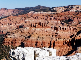
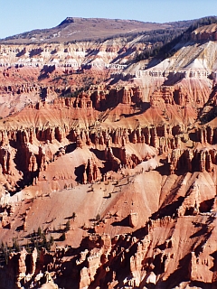
Bryce Canyon’s less publicized, higher altitude and maybe even more strikingly colored fraternal twin. Cedar Breaks NM, like its twin, is a geologic amphitheater filled with willowy multihued rock pillars, called hoodoos.
BEAUTY (8/10)
Because of proximity and physical similarity, Cedar Breaks NM beauty will forever be compared to Bryce Canyon NP. If Cedar Breaks were anywhere but near Bryce (and for geological reasons it could never be) it would be a national wonder. Cedar Breaks’ hoodoos and cliffs share the myriad hues of Bryce but they are not as dramatically situated. There are more hoodoos at Bryce and they are more compactly arranged. It is hard to throw platitudes and amazement at Cedar Breaks because it does not astound like its neighbor but it is still pretty cool.
HISTORICAL INTEREST (2/10)
Humans have lived in the area for over 9000 years but little of historic significance occurred at Cedar Breaks.
CROWDS (8/10)
Cedar Breaks NM receives a sincerely interested and sizable spillover from the area Parks. Our geology talk ballooned in numbers rather quickly. All participants paid close attention and asked the same geological questions we had. The Alpine Pond Trail gives plenty of opportunity for solitude. The path is long and the trees are so dense that fellow tourists are not an issue. The Cedar Breaks crowd all seemed happy to have stumbled upon such a beautiful and under publicized place. There were lots of smiles, no crowd claustrophobia and a tangible feeling of relaxation.
EASE OF USE/ACCESS (3/5)
Cedar City, Utah and Interstate 15 lie about 20 miles west, and straight downhill, from Cedar Breaks NM. If you are approaching Cedar Breaks NM from the east along Utah Route 12, be careful. The right turn you need to make to get to the Park is not well marked. If you start going downhill, you have gone too far. Don’t drive the whole way to Cedar City like we did.
Sadly, the Cedar Breaks are an unrequited and fleeting partner. No hikes are allowed into and around the hoodoos. A five-mile road leads to four overlooks that offer much less of a scenic variety than their counterparts at Bryce.
 CONCESSIONS/BOOKSTORE (2/5)
Not much of a book selection in the tiny Civilian Conservation Corps (CCC) built Visitor Center.
COSTS (3/5)
Cedar Breaks NM cost $3 per vehicle and is free with the National Parks Pass. The Park operates a 30-site campground along the rim during the months of July, August, September and parts of June. A campsite costs $12 but sits at an elevation of 10,500 feet. Prepare for cold, windy weather even when nearby Cedar City weathermen boast of 90-degree days.
RANGER/GUIDE TO TOURIST RATIO (5/5)
Cedar Breaks NM proactively cares about its visitors’ education and knowledge of the Park. Even though the campground had closed for the season and snow had fallen just days prior, a Ranger-led geology talk was scheduled every hour.
Three smiling Rangers eagerly made themselves available. One mingled with guests near the main overlook, one explained things at the Visitor Center and another gave us more than a few pamphlets and answered questions even though he was collecting entrance fees. The Rangers made us feel welcome and excited to be where they worked.
TOURS/CLASSES (7/10)
The Ranger-led geology talk was the first (and only) explanation of the Colorado Plateau topology that made any sense. We left museums and Rangers of Timpanogos Cave NM, Zion NP, Bryce Canyon NP and Grand Canyon NP with none of the understanding that we received from the Cedar Breaks Ranger. Granted tectonic uplift, shifting continental plates and 18 billion years of rocks is not an easy topic but our time at this site helped. Michael wants to learn more, but short of returning to school and aiming for a geology degree is not sure what he can do.
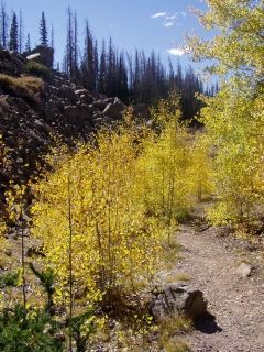
The Site also offers a terrific self-guided walking loop, the 2-mile long Alpine Pond Trail. 25 learning stations are explained in a full-color brochure available at the trailhead for $1.00 and well worth it. The walk is tranquil and offers only a momentary glance at the hoodoos. The trail centers on the 10,500-foot altitude alpine forest. From late June through August the walk passes through colorful meadows of blooming wildflowers. Goldenrod, aster, penstemon, larkspur, shooting star. Indian paintbrush, columbine, cinquefoil and wild rose. Of course, we saw none of these in September but the pictures are awful nice.
 FUN (7/10)
Everything that was lacking at Bryce Canyon NP, we found here. Attentive Rangers, easy-going geology talks, ample room to view the amphitheatre. The Alpine Pond Trail was sufficient to take our breath away, in more ways than one. The high altitude was a bit of a factor here, at least for Gab. Still, we were too disappointed that we couldn’t hike among the hoodoos.
We overheard that the young Ranger leading our talk was on her way to Alaska to start her next assignment. Despite being painfully jealous, we enjoyed spending time with her. She was more than happy to spend time with anyone who had questions after the official talk. That was pretty much all of us. Does any place in the world offer such a spectacular and diverse landscape as this region of the United States? That was the one question she couldn’t answer. We’re not sure either. Let’s say no.
WOULD WE RECOMMEND? (7/10)
If you are craving a simply worded, easy to understand explanation of the geography of this area, Cedar Breaks is your best bet. It is a shame that the way to Cedar Breaks isn’t better marked. We drove right past it. We wonder how many other tourists do. Despite its size, add Cedar Breaks to our list of hidden gems.
TOTAL 52/80
www.usa-c2c.com
© 2004-06