Lone Pine, Calif.
National Forest Website; Mount Whitney Info
 WHAT IS IT?
The eastern gateway to the top of Mount Whitney, the tallest point in the lower 48 states.
BEAUTY (10/10)
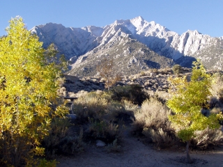
The Inyo National Forest must be the inspiration for wall murals and Bob Ross-type paintings around the world. It is easy to see why artists want to capture this beauty. Our campsite was positioned next to a gurgling stream surrounded by trees still holding on to their multi-hued fall foliage. Mount Whitney and its neighboring peaks loomed large in the distance, looking much closer than they actually are.
Sunrise showed Whitney in all its glory. Sunset lit up the barren foothills in oranges and reds. The night sky was even better. We have never seen stars like this. Camping usually puts us in our sleeping bags by nine o’clock. The brilliant field of stars, practically unspoiled by city lights made us want to stay out all night.
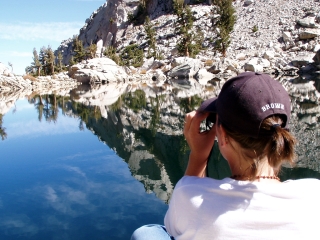
Another camper told us that when his friend saw Lone Pine Lake, she said she felt like she was in another world. We dismissed these exclamations until we got to the glacier lake ourselves. Another world indeed.
HISTORICAL INTEREST (4/10)
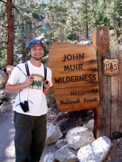
Mount Whitney Portal is part of the John Muir Wilderness, 100 miles of Sierra Nevada peaks and valleys protected under the Wilderness Act of 1964. The California Wilderness Act expanded the area which now totals 581,143 acres.
The John Muir Wilderness is one of the most heavily visited wildernesses in the United States. A lottery for permits was reinstated in 2000 to manage the vast number of people who want to experience the highest peak (14,496 ft) in the Continental U.S.
CROWDS (4/10)
Folks hiking along the Mount Whitney Trail were not as friendly as we are accustomed. Wearing only our daypacks, we even got scowls from some backpackers feeling the strain of the upward climb. As in, “you have no idea how hard this is.” A.) We do; B.) Don’t take your over-exertion out on us; and C.) Chill out. Relax. Look around you. This place is beautiful!
Perhaps we were still on a high from our Grand Canyon experience, but we didn’t appreciate the negativity on the trail, especially since we always gave loaded packers the right of way.
 EASE OF USE/ACCESS (1/5)
Numerous Rangers told us that, “comparatively speaking, Mt. Whitney is rather accessible.” Compared to what, Mt. McKinley in Alaska? The town of Lone Pine, near the Mount Whitney access point, is almost 120 miles north of the town of Mojave along U.S. Route 395. It is then a further 90 miles until you get to Interstate 5 and the Los Angeles sprawl of the San Fernando Valley. The Sierra Nevada Mountains have always been an effective terrific travel barrier.
Perhaps the Rangers meant that it does not take advanced mountaineering skill to get to the top of Mt. Whitney. Even so, getting a permit to hike up the side of the mountain is no guarantee. Because of the ascent’s popularity, strict limits have been placed on the number of people allowed on the mountain’s side. Unless you have a permit, you are only allowed to hike up 2.8 miles from the Mt. Whitney trailhead to Lone Pine Lake.
We asked about a Mt. Whitney permit and we met with similar responses to our Grand Canyon inquires. See our review for more info. First-come, first-served permits seemed to be available.
CONCESSIONS/BOOKSTORE (1/5)
The Inyo National Forest Ranger station is all about issuing permits and taking care of administrative business. There is no gift shop.
COSTS (4/5)
Our campsite was an affordable $8 on weeknights. $10 for Friday and Saturday. There is no charge to hike as far as Lone Pine Lake. Going further requires a permit, which is $15 per person per trip into the Whitney Zone of the protected Wilderness area.
Other campgrounds in the Inyo National Forest vary in price from $14 to free for those that are out of season or have no potable water or facilities (meaning toilets).
RANGER/GUIDE TO TOURIST RATIO (3/5)
We met three Forest Rangers at the Inter Agency Visitor Center in the town of Lone Pine. They seemed well equipped to handle the minimal crowd late in the summer season.
This National Forest is divided into two zones, each with two Ranger Stations. We didn’t go far enough into the forest to encounter any of these outposts.
TOURS/CLASSES (3/10)
No tours or classes were offered at the Lone Pine campground. The Inter Agency VC in Lone Pine had plenty of free maps and single page guides to wildlife, birds and plants of the area, but not much more.
At the Mt. Whitney trailhead are a series of large outdoor panels, listing the distances and altitudes of points along the trail, helpful tips and reminders for hikers, a scale for you to weigh your backpack, and two pictures of a popular high elevation rest stop. The first picture shows clear skies, sunshine and what looks to be a relatively mild day. The second snapshot shows the same area covered in windblown snow and icy rain. The photographs were taken on the same day, within hours of each other. Lesson learned. While on Mt. Whitney, be prepared and don’t take anything for granted.
FUN (9/10)
We enjoyed hiking, watching an amazing display of shooting stars two nights in a row and relaxing by a sunny creek bed without ever getting too far from the conveniences of Lone Pine. We hardly even strayed from our original route. We owe Ranger Alisa at Manzanar NHS our thanks for being insistent that we check out Inyo NF.
 WOULD WE RECOMMEND? (9/10)
National Forests are not officially part of our itinerary for this trip. Not because they lack in beauty or importance; simply because we had to limit the scope. There is only so much one can do in two years. Mount Whitney Portal in the Inyo National Forest is worth making an exception. This place is beautiful. The campgrounds are inexpensive and comfortable. Last minute permits to hike to the top of Mount Whitney are not impossible to get. We opted not to go to Yosemite, Kings Canyon or Sequoia NPs this month since the weather gets pretty unpredictable in the higher altitudes. If they are anything like what we’ve seen on this side of the Sierras, we can’t wait to go.
Note: Turns out we made the right decision when we chose to stay at a lower altitude. Days after we decided not to seek a permit to summit the crest of Mt. Whitney, several hikers were stranded in the Inyo NF due to a surprise snow storm. That same storm left two climbers dead in Yosemite. Yet another reminder that no matter who you are, Mother Nature always has the upper hand.
TOTAL 48/80
www.usa-c2c.com
© 2004-06